
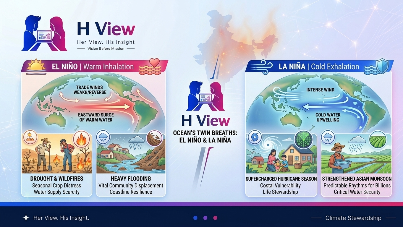
El Niño and La Niña are often described as opposite phases of a climate pattern in the tropical Pacific. The shorthand is useful, but it can leave readers with the wrong impression that each event produces a fixed set of outcomes everywhere. In reality, the El Niño–Southern Oscillation (ENSO) shifts ocean temperatures, winds and tropical rainfall, and its effects depend on season, location and other climate patterns.
Those shifts matter because seasonal rainfall supports farms, reservoirs, fisheries, transport and household incomes. Understanding ENSO does not let anyone predict the weather for a particular town months in advance. It does help explain why forecasters monitor the tropical Pacific and why communities should read seasonal outlooks alongside local warnings and observations.
What ENSO means
ENSO is a recurring but irregular interaction between the tropical Pacific Ocean and the atmosphere above it. Scientists track sea-surface temperatures, winds, air pressure and rainfall across the equatorial Pacific. NOAA describes El Niño as the warm phase, La Niña as the cool phase, and conditions that meet neither definition as ENSO-neutral. The events generally last several months and do not follow a reliable calendar.
During neutral conditions, easterly trade winds usually push warm surface water westward toward Indonesia and Australia. Cooler water rises near the eastern Pacific as deeper water replaces some of the surface water carried away. This circulation helps shape where clouds and tropical rain form. ENSO changes the strength of these winds and the distribution of warm water, which can move rain patterns and influence atmospheric circulation well beyond the Pacific.
What changes during El Niño?
In an El Niño phase, the central and eastern equatorial Pacific become warmer than their long-term average, and the trade winds weaken. The warm pool and the strongest tropical rainfall shift eastward. That rearrangement can change storm tracks and seasonal rainfall in distant regions. NOAA’s overview explains the ocean–atmosphere mechanism, while its ENSO FAQ cautions that a climate signal is not a single-event forecast.
For example, El Niño is often associated with wetter conditions in parts of the southern United States and along portions of coastal South America, while parts of Australia and Indonesia can face a higher chance of dry conditions. These are broad tendencies, not guarantees for every year or district. A local outcome can differ because of the event’s strength and timing, nearby ocean conditions, topography and short-term weather systems.
In India, El Niño is commonly discussed in relation to the southwest monsoon, but the connection is not deterministic. Research published in the India Meteorological Department’s journal examines how ENSO interacts with other influences on monsoon rainfall. The practical point is that an El Niño alert should prompt attention to official seasonal forecasts and water planning, not a claim that a particular state will receive a specific amount of rain.
What changes during La Niña?
La Niña is marked by cooler-than-average surface water in the central and eastern equatorial Pacific, with stronger trade winds tending to push warm water farther west. Upwelling of cooler water off South America can also strengthen. The resulting atmospheric pattern is broadly different from El Niño, but its impacts still vary by region and season.
La Niña is often linked with wetter conditions in parts of Australia and Indonesia and with an increased likelihood of an active Atlantic hurricane season. Neither result is automatic. Other ocean temperatures, wind shear, the West African monsoon and the timing of the ENSO phase also influence hurricane activity. In India, La Niña has often coincided with stronger southwest monsoon rainfall, yet the all-India average does not describe every state, month or crop-growing area.
ENSO phases can also persist or change across seasons. A multi-year La Niña may affect planning differently from a brief event, while local rainfall can still be uneven within a season. Farmers and water managers need regional forecasts and updates, since an ocean pattern is only one part of the conditions that determine rainfall on the ground.
Why a global pattern does not create one global forecast
The World Meteorological Organization notes that ENSO impacts differ by place and can change with event intensity, duration, season and interactions with other climate modes. A strong event does not mean every place experiences an extreme. Even during ENSO-neutral conditions, floods, droughts and heat can occur because of other climate drivers and local weather.
This distinction matters in public communication. Saying “La Niña brings more rain” without naming the region, season and uncertainty can create false confidence. A responsible report should explain whether it is describing an observed condition, a probability in a seasonal outlook or a confirmed local impact. People should use alerts from their national meteorological agency for decisions about travel, farming, health and emergency preparation.
How communities can use ENSO information
Seasonal outlooks are most useful when they inform flexible decisions rather than dictate a single response. Farmers can compare forecasts with local advisories before choosing planting dates or varieties. Water authorities can review reservoir levels, demand and conservation plans. Emergency services can use an elevated risk outlook to check communications, drainage and evacuation readiness, while continuing to rely on official short-range warnings for immediate action.
Households can take practical steps that make sense for their local hazards: follow weather alerts, protect drinking water, prepare for heat or heavy rain, and keep essential contacts available. ENSO alone cannot tell a family whether a storm will hit its street. Local forecasts and trusted public agencies provide the detail that a Pacific-wide index cannot.
For India, this is also why monsoon conditions should be read with local context. The IMD’s peer-reviewed analysis of the 2020–2022 “triple-dip” La Niña period shows that researchers study the relationship using observations and forecast systems rather than treating the climate phase as a simple rainfall switch. Readers interested in the wider environmental stakes can also explore H View’s discussion of climate change and resource depletion.
What ENSO can—and cannot—tell us
ENSO is a valuable source of seasonal climate information, not a substitute for local forecasting. It can shift the odds of certain rainfall and temperature patterns across broad areas. It cannot specify the exact day a monsoon will arrive, how much rain one district will receive, or whether a particular storm will form. Those questions require different observations, models and update schedules.
Readers can keep the distinction clear by checking the issue date and geographic scope of a forecast, noting whether it describes a probability or a confirmed event, and following updates from official meteorological agencies. NOAA’s plain-language ENSO explainer, its ENSO FAQ, the WMO’s overview of El Niño and La Niña, and research in the IMD’s MAUSAM journal provide useful starting points.
H View perspective
The most useful lesson is not that one phase is “good” and the other “bad.” Both can bring risks and opportunities that vary across communities, and neither removes the need for local evidence. Clear coverage should connect the science to decisions people can make, explain uncertainty in ordinary language, and avoid turning a tendency into a promise. That reader-first approach is part of H View’s editorial policy.
Frequently asked questions
Are El Niño and La Niña regular cycles?
No. They recur irregularly, often every few years, and their duration and intensity vary. Neutral periods may occur between events.
Does El Niño always reduce India’s monsoon rainfall?
No. El Niño is associated with a higher chance of weaker monsoon conditions in some analyses, but it does not determine rainfall on its own. Other climate patterns and regional factors can change the outcome.
Does La Niña guarantee an active Atlantic hurricane season?
No. La Niña can favor conditions that support Atlantic hurricane activity, but sea-surface temperatures, wind shear, atmospheric moisture and other factors also matter. Forecasts express probabilities, not guarantees.
Where should readers check for current alerts?
Use the national meteorological service and local emergency-management guidance for your location. ENSO background explainers help with context; current agency forecasts and warnings should guide immediate decisions.